- The UK has 13 overseas territories.
- The Cayman Islands in the Caribbean is the most populous British overseas territory.
- The British Antarctic Territory is the largest British overseas territory by land area, but has no permanent human population.
- Gibraltar, situated on the southern coast of the Iberian Peninsula, is the most densely populated British overseas territory.
People used to say that the sun never sets on the British Empire. Indeed, at the height of British imperialism, the United Kingdom had possessions in nearly all the corners of the world, including large parts of Asia and Africa. Today, however, most of the territory that the UK once controlled now consists of independent countries. The UK does, however, still maintain control over 13 mostly small territories in different parts of the world.
Anguilla
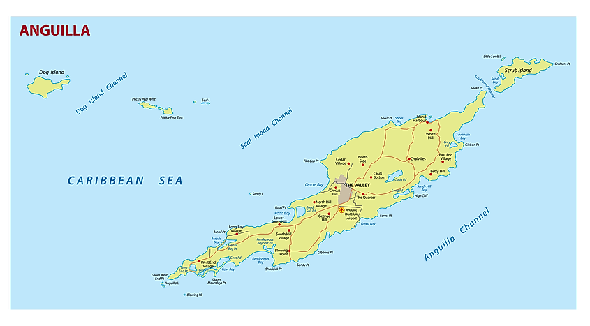
Anguilla is the most northerly of the Leeward Islands in the eastern Caribbean. The island’s land area is just 91 sq. km. The population of Anguilla is just over 15,000. The island was first colonized by British settlers in 1650. In the early 19th century, the UK incorporated Anguilla into a single entity with St. Kitts and Nevis. In 1980, however, the island was given status as a separate territory. Today, the economy of Anguilla is highly dependent on tourism, offshore banking, lobster fishing, and remittances from emigrants.
Bermuda
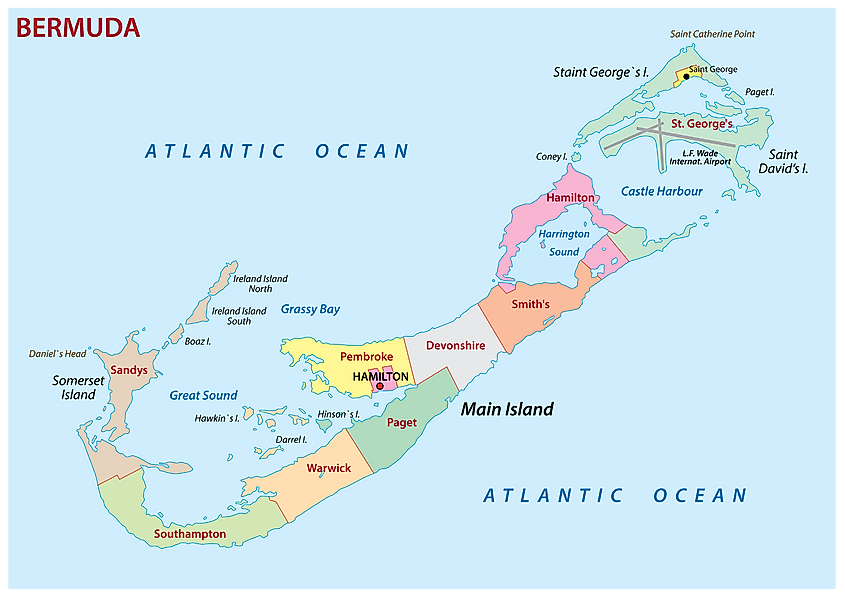
Bermuda is located in the Atlantic Ocean, about 1,050 km east of the US state of North Carolina. The territory is an archipelago of 7 islands, and about 170 other named islets and rocks. Bermuda’s total land area is 54 sq. km, and its population is about 62,000. The territory was first settled in 1609, by English colonists who originally planned to settle in what is now the U.S. state of Virginia, but became shipwrecked in Bermuda. The territory has been a self-governing British colony since 1620, which means that it is the oldest of the UK’s overseas territories. Bermuda was granted the option of independence in a 1995 referendum, but it was rejected.
British Antarctic Territory
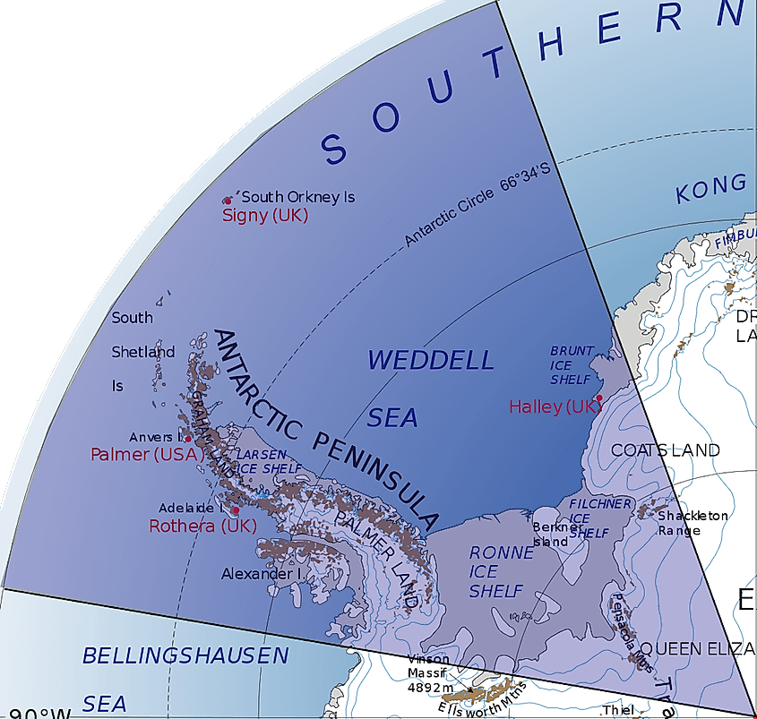
As its name implies, the British Antarctic Territory, or BAT, is located in Antarctica. It is the UK’s largest overseas territory, with a land area of 1,709,400 sq. km. This includes the northern tip of the continent, closest to the southern tip of South America. The BAT has no permanent human population in the territory, though there are three scientific stations and a historical base called Port Lockroy, which is now a popular tourist destination. More than 99% of the BAT is covered by ice.
British Indian Ocean Territory
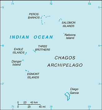
The British Indian Ocean Territory is located in the Indian Ocean, about halfway between East Africa and Indonesia. It is composed of 58 islands that cover 640,000 sq. km of the ocean, though its total land area is only 60 sq. km. Today, there is no indigenous population in the territory. In the 1960s and 70s, the people who lived on the island, known as Chagossians or Ilois, were relocated to the African island countries of Mauritius and the Seychelles. The territory now serves primarily as a military base for the US and UK.
British Virgin Islands
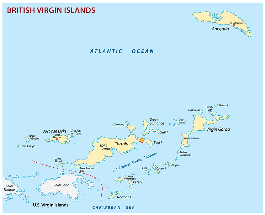
The British Virgin Islands consist of 50 islands and cays, situated east of the U.S. territory of Puerto Rico. The US Virgin Islands lie to the west and south of their British counterparts. The main islands of the British Virgin Islands are called Tortola, Virgin Gorda, Anegada, and Jost Van Dyke. The islands’ total population is approximately 30,000. The British Virgin Islands were first inhabited by the indigenous Arawak and Carib peoples. The Dutch settled the islands in 1648, but the British annexed them in 1672. Between 1872 and 1960, the British Virgin Islands were administered as part of the overseas territory known as the Leeward Islands. In 1967, the islands were given autonomy and status as a separate British colony. The economy of the British Virgin Islands is highly dependent on tourism, which makes up 45% of its national income. The U.S. dollar is the islands’ currency.
Cayman Islands
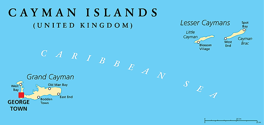
The British overseas territory of the Cayman Islands is located south of Cuba and northwest of Jamaica. The territory consists of three islands, the largest of which is Grand Cayman. Its total land area is 264 sq. km, and its total population is an estimated 66,000, making the territory the most populous of the UK’s overseas territories. The Cayman Islands were first colonized by the British in the 18th and 19th centuries. They were administered as part of Jamaica after 1863. In 1959, the islands became part of the territory known as the Federation of the West Indies. This federation dissolved, however, in 1962, and the Caymans became a separate British territory. Although the territory of the Cayman Islands is well-known as being a tourist destination, it also has a reputation for being a tax haven and offshore financial center.
Falkland Islands
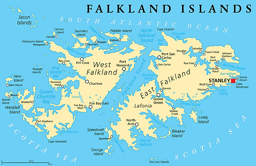
The Falkland Islands, or Islas Malvinas, as they are called in Spanish, are located in the South Atlantic Ocean, about 480 km northeast of the southern tip of South America. The territory consists primarily of two main islands, East Falkland and West Falkland. The total land area of the Falklands is 12,173 sq. km. Its population is about 3,500. First sighted by an English navigator in 1592, the islands were not settled by Europeans until 1764, when the French began settling there. The islands were turned over to Spanish control two years later. From this time forward, the UK and Spain each claimed ownership of the Falklands. In 1833, the British established naval garrison on the islands. Later on, what was originally a dispute between the UK and Spain became one between the UK and Argentina, the latter of which claims ownership of the islands to this day. In 1982, Argentina invaded the Falklands starting a war that ended with the British retaking the islands.
Gibraltar
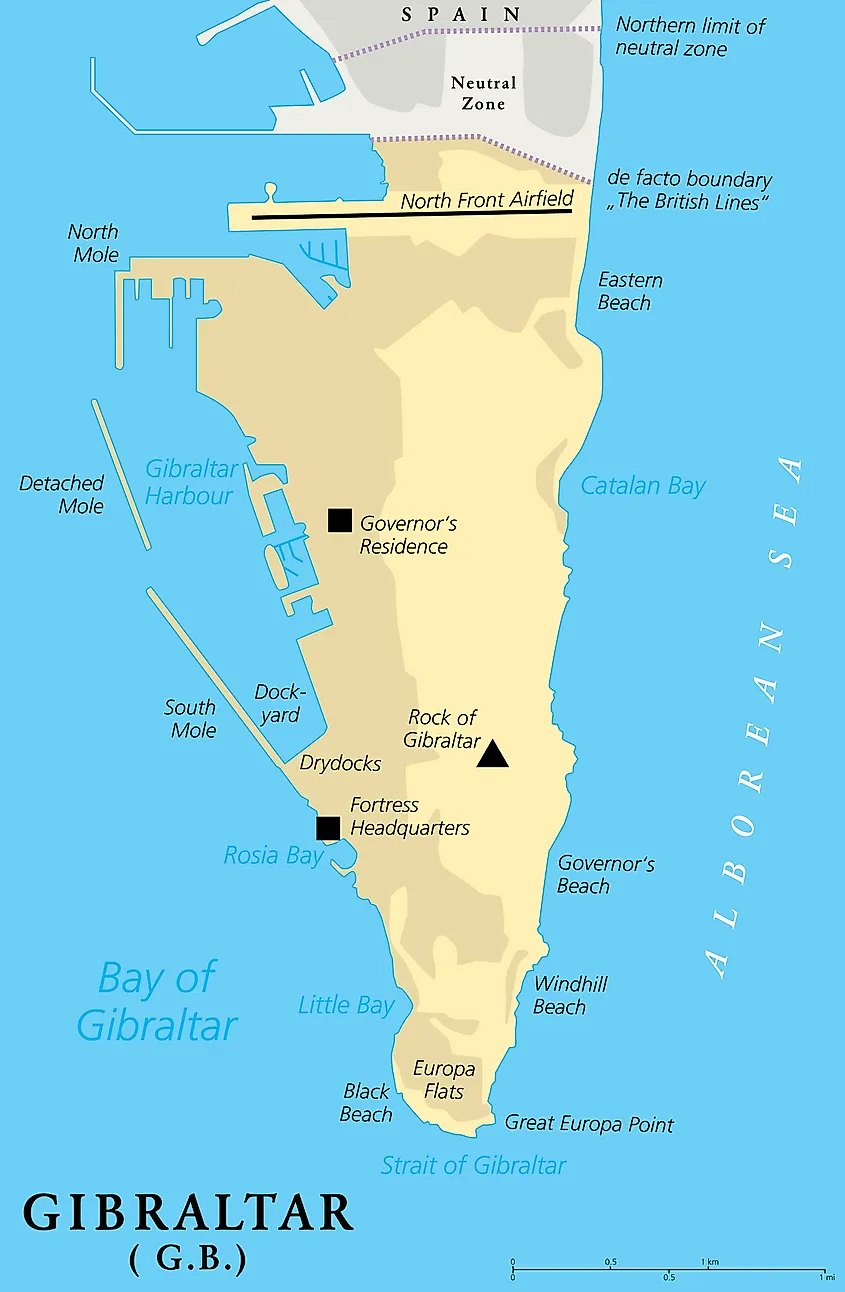
Gibraltar is a tiny enclave on the southern coast of the Iberian Peninsula. It faces Spain to the north, the Strait of Gibraltar to the south, the Mediterranean Sea to the east, and the Bay of Gibraltar to the west. The territory is just 10 sq. km in land area, but more than 33,000 people live there, making it the most densely populated British overseas territory.
Montserrat
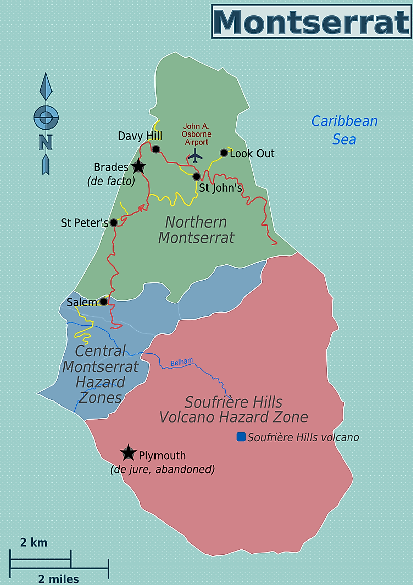
The small island of Montserrat is a British overseas territory located southeast of St. Kitts and Nevis, southwest of Antigua and Barbuda, and northwest of the French overseas territory of Guadeloupe. The island is just 50 sq. km in land area, and has a population of approximately 5,000 people, making it the smallest and least populous British overseas territory in the Caribbean. In 1995, two thirds of Montserrat’s population fled when the island’s Soufriere Hills Volcano erupted.
Pitcairn Islands
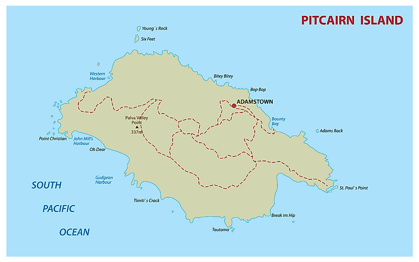
Located in the South Pacific, about 2,170 east south-east of Tahiti and just over 6,600 km from Panama, the Pitcairn Islands consists of four islands: Pitcairn, Henderson, Ducie, and Oeno, though Pitcairn is the only inhabited island. The total land area of the territory is 47 sq. km. Just 50 people live on the island. They are the descendants of the mutineers of the HMAV Bounty and their Tahitian companions.
South Georgia And The South Sandwich Islands
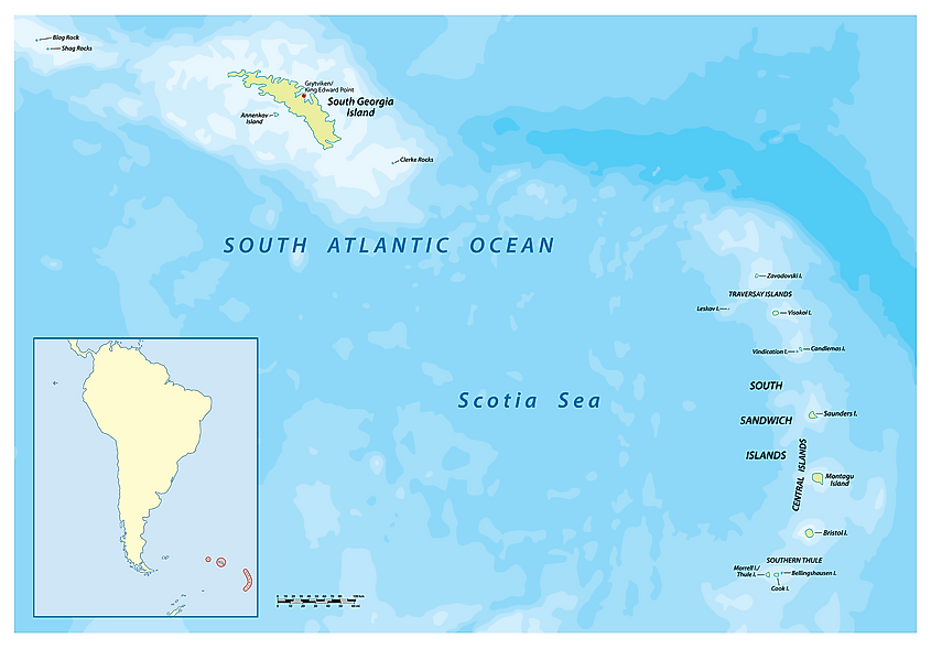
South Georgia and the South Sandwich Islands is an island archipelago located 1,000 km east of the Falkland Islands, in the South Atlantic Ocean, not too far from the shores of Antarctica. The islands have been administered by the UK since 1908. This island territory has no permanent human population. There was a whaling station in the territory, known as Grytviken, but it has since been converted to a research station. South Georgia and the South Sandwich Islands have become increasingly popular with tourist cruises. The islands have a large populations of seals and birds.
St. Helena, Ascension And Tristan Da Cunha
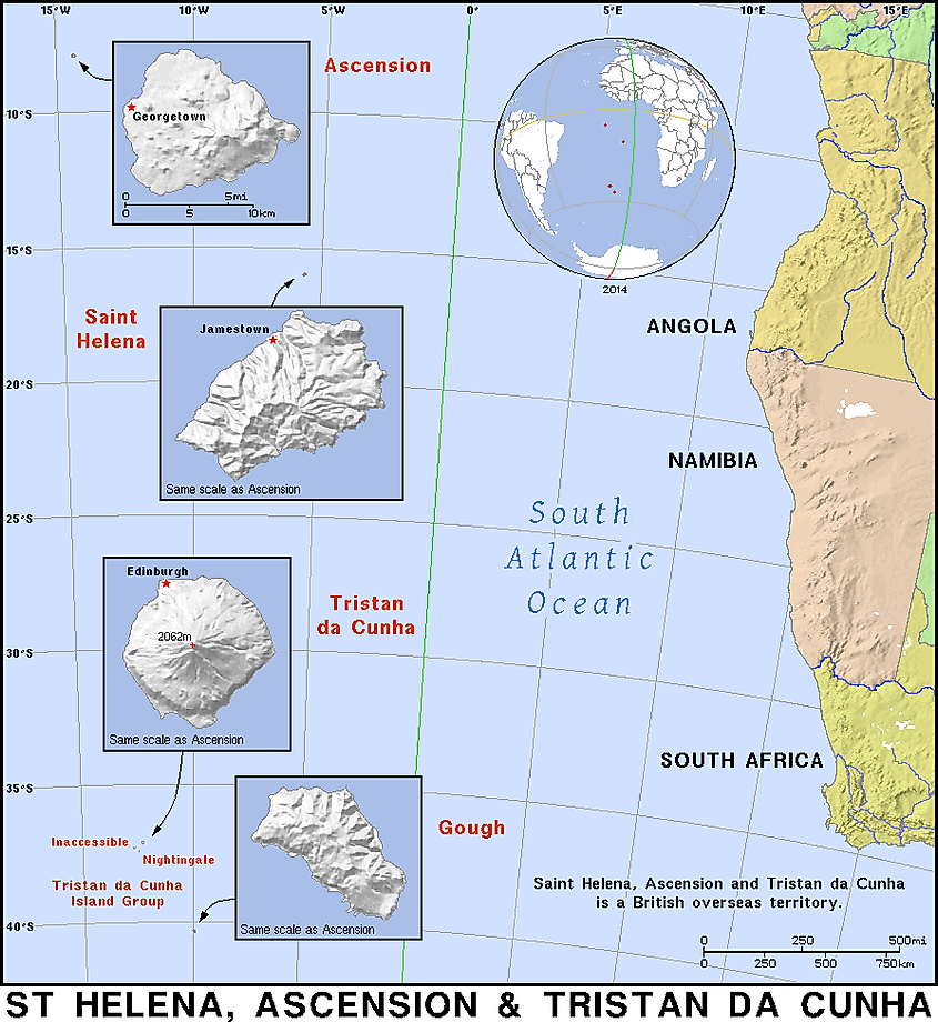
St. Helena, Ascension and Tristan da Cunha are three islands situated in the South Atlantic Ocean, midway between South America and Africa. The total land area of the islands combined is 394 sq. km. About 4,200 people in total live in the territory, most of whom live on St. Helena, as it is the largest of the three islands. St. Helena itself is best known for being the place where French emperor Napoleon Bonaparte was exiled following his defeat at Waterloo in 1815.
Turks And Caicos Islands
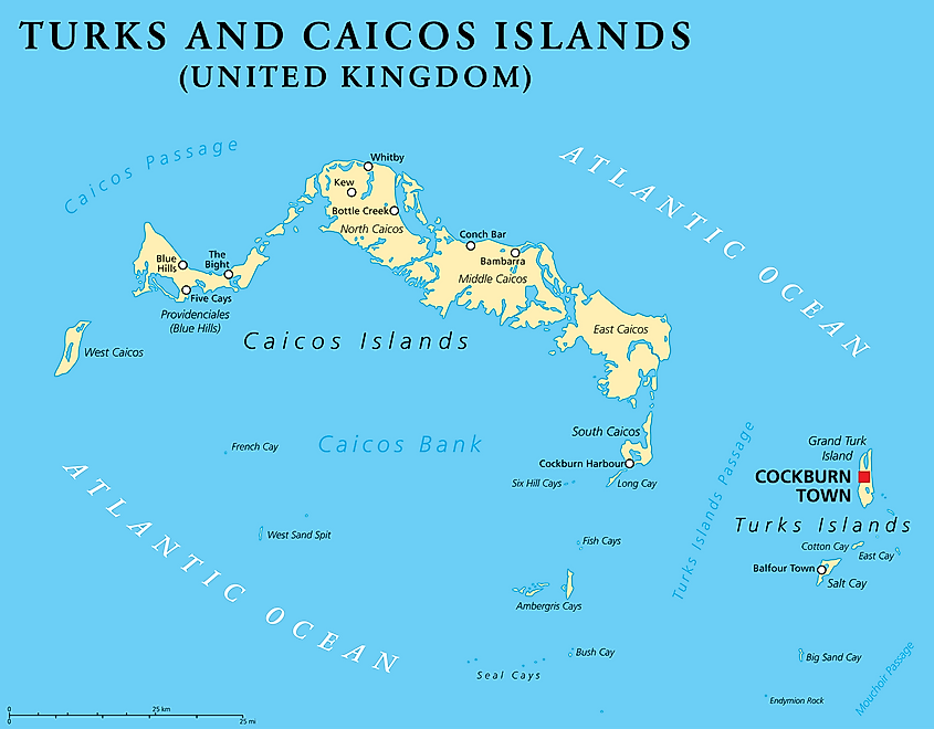
The Turks and Caicos Islands are situated southeast of the Bahamas, east of Cuba, and north of the island of Hispaniola, which is shared by the countries of Haiti and the Dominican Republic. Though technically located in the Atlantic Ocean, this British overseas territory is generally considered to be part of the Caribbean. The Turks and Caicos Islands consists of two groups of islands. In total, there are 100 named islands and cays in the territory. The total land area of the Turks and Caicos Islands is 950 sq. km, which makes it the largest British overseas territory in the Caribbean. Its population is approximately 39,000. The islands were first settled by indigenous people from South America. Subsequently, the Arawak and Carib peoples also settled there. The first European settlers arrived from Bermuda in 1678. In 1799, the British annexed the islands and administered them as part of the Bahamas, but in 1959, the Turks and Caicos Islands became a separate colony. Like many Caribbean islands, the economy of the Turks and Caicos Islands is based on tourism, financial services, and fishing.


 Users Today : 499
 Total views : 468974