| S. No | National Highway | Distance (in km) | Route |
|---|---|---|---|
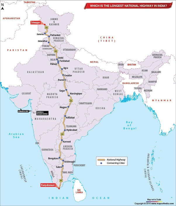
| 1 | NH 44 (old NH 7) | 3,745 | Srinagar to Kanyakumari |
| 2 | NH 27 | 3,507 | Porbandar in Gujarat to Silchar in Assam |
| 3 | NH 48 (old NH 8) | 2,807 | Delhi to Chennai |
| 4 | NH 52 | 2,317 | Sangrur, Punjab to Ankola, Karnataka |
| 5 | NH 30 (Old NH 221) | 2,040 | Sitarganj in Uttarakhand to Ibrahimpatnam in Andhra Pradesh. |
| 6 | NH 6 | 1,873 | Jorabat in Meghalaya and terminates at Selling in Mizoram |
| 7 | NH 53 | 1,781 | Hajira in Gujarat and Pradip port in Odisha. |
| 8 | NH 16 (Old NH 5) | 1,711 | East coast of West Bengal to Chennai in Tamil Nadu. |
| 9 | NH 66 (Old NH 17) | 1,622 | Panvel and terminates at Kanyakumari |
| 10 | NH 19 (Old NH 20) | 1,435 | Delhi to Kolkata |
| 11 | NH 34 | 1,426 | Gangotri Dham in Uttarakhand to Lakhnadon in Madhya Pradesh |
Longest Highway In India: NH 44
 image
imageLongest Highway In India
The National highways in India are a network of trunk roads that are owned by the Ministry of Road Transport and Highways. It is constructed and managed by the National Highway Authority of India (NHAI), the National Highways and Infrastructure Development Corporation (NHIDCL), and the public works departments (PWD) of state governments. India has 142,126 km (88,313 mi) of National Highways as of April 2019. Indian national highways connect every major city of India from north to south to east to west.
India has Golden Quadrilateral (GQ). GQ is a national highway network that connects the major industrial, agricultural, and cultural centers of India. It forms a quadrilateral connecting the four major metro cities of India, viz., Delhi (north), Kolkata (East), Mumbai (west), and Chennai (south).
Longest Highway In India: Facts
- ➤India has the second-largest road network in the world,
- ➤There are over 200 national highways and their cumulative length adds up to 101,011 km. The total length of state highways in India adds up to 1,31,899 km.
- ➤The main highway is of a 2-digit number and all the highways that are numbered in three digits are technically branches to the main highway.
➤For example, 144 number highway is a secondary branch of highway number 44. These are further broken into sub-divisions and named with a suffixed alphabet, like 144A, 244A, etc.
- ➤The national highways consume only 1.8% of all Indian roads. Yet they control 40% of road traffic in the country.
- ➤Colors in National Highways:
*Yellow and white colors are for national highways.
*Green and white for state highways
*Black and white are for the city highway
➤NH 118 along with NH 548 are the shortest national highway in India. NH 118 connects the towns Asanbani and Jamshedpur in the state of Jharkhand, running for a distance of only about 5 km. The NH 548 traverses the state of Maharashtra for about 5 km of length.
- ➤Leh-Manali Highway is the world’s second highest-altitude motor highway which connects Shimla in Himachal Pradesh to Leh in Jammu and Kashmir.